Thinking Ahead & Being Prepared – by Gavin M
April, this year, 2012, will see the centenary of the sinking of the Titanic. On its maiden transatlantic voyage in 1912, on the 14th of April at twenty minutes before midnight, during a flat calm and moonless night, the Titanic, travelling at 21 knots, hit an iceberg – buckling plates and rupturing rivets for 300 feet below the waterline. Six forward compartments were quickly flooded leading to the sinking of the Titanic, two and a half hours later. Of a total of 2,224 people aboard Titanic only 710, less than a third, survived and 1,514 perished in the freezing waters of the North Atlantic. Many of the crew were from my home town of Southampton and I recently discovered one of the crew, Harold Charles William Phillimore, second class steward, lived in the house where I am now writing this when he signed on for the fateful voyage – departing from Southampton via the Solent to Cherbourg, Cobh and on towards New York.
Some of the factors leading to the sinking of the Titanic and death of so many [1] included; excessive speed on a night when it was difficult for the lookouts to spot icebergs in sufficient time for the Titanic to take avoiding action, insufficient manoeuvrability mainly due to the small size of the rudder, bulkheads which stopped short of the deckhead (allowing seawater to flood from one ‘watertight’ compartment to the next), an inadequate abandon-ship plan and lifeboats only sufficient for just over half of the passengers and crew aboard.
So what, you may ask, has this to do with canoe sailing?
Well, many of the issues contributing to the widespread loss of life when the Titanic sank were addressed by the publication in 1914 of the International Safety of Life at Sea Convention (SOLAS) which was directed at preserving life onboard any ship or craft going to sea. SOLAS required ships to comply with minimum safety standards of construction, equipment and operation. Successive revisions have extended the scope of SOLAS [2] and since 2002 Chapter V, which deals with the Safety of Navigation, has applied to “all ships on all voyages”. This includes all UK pleasure vessels (with no lower limit as to size of craft) going to sea. In this context ‘going to sea’ does not include sailing on “categorised waters” which include most natural harbours, estuaries and other sheltered waters – so a canoeist, canoe sailor or any recreational sailor is not legally obliged to comply with SOLAS, unless voyaging on the open sea outside of sheltered coastal waters. Nevertheless, some parts of SOLAS are very relevant to any canoe sailing trip, no matter how short or how sheltered the sailing area.
Regulation 34 of SOLAS Chapter V requires masters of vessels to plan voyages. According to the UK Maritime and Coastguard Agency (MCA) this means “making a careful assessment of any proposed voyage, taking into account all dangers to navigation, weather forecasts, tidal predictions and other relevant factors including the competence of the crew” – which sounds a bit daunting and seems a bit unnecessary for a cruise across Windermere (especially the bit about tidal predictions). However, applying the principle to canoe sailing just means making a conscious effort to think through a plan for the voyage or trip. This process can be a brief mental check list for short trips or a detailed plan with written notes for sailing longer expeditions.
Put simply; passage planning is about thinking ahead and being prepared. Thinking through the intended route, what might happen and how you would deal with it, will keep you and your crew much safer than sailing without a plan. This is a form of ‘on the water’ risk assessment. However, it’s also about checking the trip/voyage is achievable and practicable. A passage plan may help avoid an unpleasant time struggling against a foul tide in deteriorating weather conditions or paddling home in the dark because the wind has died. So you will also tend to have more enjoyable sails and be able to relax a bit more if you’ve planned beforehand.
Four factors in staying safe on any sailing trip are;
- The Boat – is it sound, seaworthy, of suitable construction and properly equipped for the intended voyage?
- The Skipper – necessary experience, knowledge and ability to deal with any eventualities?
- The Kit – what additional items of clothing and equipment may be needed on the voyage?
- The Plan – have the conditions, possible hazards and eventualities for the trip to the café, the coastal day sail or a week long voyage been properly thought through and planned for?
This article is mainly about passage planning but this necessarily includes an appraisal of the boat, the skipper and the kit taking into account the voyage and likely conditions. To illustrate passage planning in practice I’ll look at two scenarios. Firstly, a sail down Coniston – from Coniston Hall campsite towards [3] Peel Island and return. Secondly, a coastal sail in the Solent and English Channel, also including a portage.
Coniston Hall towards Peel Island and return
Times and Distances: From Coniston Hall to Peel Island is just less than 3 nautical miles (NMs). A nautical mile is about 15% longer than a statute mile. It is often a more convenient distance unit for sailing as we tend to think of boat speed in knots and one knot is one nautical mile per hour. The wind on Coniston tends to blow up or down the lake so one direction or the other is likely to involve tacking upwind, which usually means sailing about 50% further to cover the same distance to windward. So, whereas the downwind leg would be 3NM, the upwind leg would be 4½NM through the water. Assuming a boat speed of 3 to 4 knots in average conditions this would mean something like 1¼ to 1½ hours sailing upwind and about 1 hour or a bit less downwind. However, wind strength is a major influence on boat speed so it could take longer in light winds and possibly a bit less in a fresh breeze.
Weather: Always make sure you have a recent weather forecast before setting sail. We’ll assume the forecast is the same as for the 2011 ‘Last Chance’ Coniston Hall OCSG meet which, as I recall, was; southerly, force 3, gusting 5 and decreasing later. The temperature was mild for the time of year and there was a possibility of light showers following the heavy rain earlier in the day. A fresh or gusty wind can mean greater leeway when going to windward (the boat going sideways a bit due to the pressure of wind on the sail) and more tacks needed to reach an upwind destination. So this could mean a bit longer sailing upwind. One of the dangers of sailing downwind in strong breezes is that the wind strength appears to be much less when going in the same direction as the wind – leading to a risk of making a major underestimate of the difficulty of sailing in the opposite, upwind direction. The first leg of the voyage to Peel Island on the 23rd of October was upwind but if setting off downwind it is often sensible to check progress to windward can be sustained before committing to sailing downwind, otherwise you could find it very difficult or impossible to return to your startpoint. Additionally, you are much less likely to be able to assist a capsized boat and sailor if you cannot sail upwind. Like Roger running in broad sweeps across the field as he tacked uphill and upwind to Holly Howe Farm (at the beginning of ‘Swallows and Amazons’), think of sailing upwind like zig-zagging uphill and downwind like coasting downhill, with wind strength a bit like the steepness of the hill.
Weather and Navigational Hazards: Remember that weather forecasts are often wrong so allow for the possibility of the wind being stronger than the forecast. The real wind strength often turns out to be one level more or less on the Beaufort scale – so a forecast of force 3 gusting 5 could easily turn out, in reality, to be a force 4 gusting 6. The upper safe limit of wind strength for sailing canoes used to be regarded as force 5 – when beam reaching under a heavily reefed sail to safety or dropping the rig and paddling to safety was advised. However more lately, the developments of readily and quickly reefed rigs, sailing canoes better able to cope with rough conditions and the frequent use of Solway Dory mini outriggers or other outriggers/amas has extended the sailing wind range for experienced or very experienced canoe sailors to force 6 and occasionally force 7 for brief periods. But remember; the wind strength is often greater than the forecast and sea conditions/wave height on exposed waters can make a force 5 extremely challenging. There are no particular navigational hazards on Coniston to worry about, other than the possibility of the occasional small submerged rock close to the shore to watch out for and the odd launch passing up or down the lake.
Navigation Plan: For the voyage considered, a chart or map for Coniston is not essential as it would be difficult to get lost (although it would pay to have at least looked at a map of the area before setting off).There are only two ways to go – up or down the lake. For voyages of longer duration, particularly in winter, it pays to be aware of sunset times and the need for some sort of light (which can be a torch, or preferably an all-round white, or even a tricolour navigation light) if return in the dark is a possibility.
The Skipper: The OCSG competence level recommended for a voyage similar to Peel Island and back in the conditions forecast for the 23rd Oct is level 2. But had the wind been greater than forecast it could have been a competence level 3 sail. See http://www.ocsg.org.uk/safety/competence-levels/ for more on what level of sailing ability and skills are required for each level. Before setting out it is important to consider whether the anticipated conditions (taking into account factors such as the weather, degree of exposure to wind and waves, length of the trip and possibilities of assistance if necessary) are within your ability range. Unless you are sailing a boat which cannot capsize in the possible conditions, it is important to be able to recover from a capsize.
Your Boat: Some questions to consider are: Are your boat, rig, foils and fittings all capable of handling sailing and capsizing loads? Is the rig able to be readily reefed afloat? Does your boat have sufficient buoyancy (end and amidships side buoyancy) to permit righting and climbing back on board after a capsize without being swamped? How does your sailing canoe perform in moderately rough conditions and is there enough freeboard (and possibly deck) to help avoid being swamped by waves coming aboard? For more see the pages www.ocsg.org.uk/safety/the-boat/ and www.ocsg.org.uk/safety/general discussion-on-safety/.
What kit to take: A buoyancy aid with whistle, paddle and bailer are essentials for any sail, no matter how short or benign the conditions. For the sail to Peel Island additional kit could have included; some spare clothing stuffed into a drybag (in case of a weather deterioration), a chocolate or cereal bar, an additional means of calling for help such as a personal day/night flare carried in your buoyancy aid and a throwing line. For more advice on what kit to take see www.ocsg.org.uk/safety/calling-for-help-safety-/ Clothing for sailing should not only take into account air temperature but also water temperature, bearing in mind how quickly you may or may not be able to get out of the water following a capsize. On the 23rd Oct the Coniston water temperature was likely to have been 10°C. Immersed in water at this temperature, if in normal clothing, you may start to find it difficult to climb back aboard after 20 minutes with complete incapacity and exhaustion possibly occurring in under an hour). A wetsuit or drysuit will help avert cold water shock and greatly delay the onset of hypothermia.
What if: The most obvious risk is that of a capsize. Being able to self-recover from a capsize or to help others recover are important safety skills which should be practised at least once a year but preferably more often and in a variety of conditions. See www.ocsg.org.uk/safety/capsize-recovery-peer-rescue/ for more on how to deal with a capsize. A rig or gear failure could mean an ‘on the water’ repair or paddling back to the start, or to shore – so it is worth thinking about how you’d deal with these scenarios. The danger which often concerns me the most is becoming separated from the boat by falling overboard. In this situation a personal flare carried in your buoyancy aid could be a very effective means of alerting others in the vicinity. Buddying up increases safety and means that buddy group members can assist or stand by in the event of a capsize or gear failure. Signing on and off the water at OCSG events formalises the buddying up process and ensures the alarm can be raised should you fail to return by the time stated.
Sailing the Plan: The value of a plan would be greatly reduced or lost if it were not followed – so it is important to ‘sail the plan’ and to monitor progress against the plan. If things don’t work out as anticipated, a change in the weather necessitates a rethink or some other destination appeals, then change the passage plan – making a new appraisal of the new route, times, distances, possible hazards, resources and so on. Usually, it is worth having a ‘plan B’ ready in advance. In a simple case this could just consist of being prepared to make an early return.
Hurst Spit towards Southampton Water – via the Needles, a portage, the River Yar & the Solent
Earlier last year in April, during the short spell of fine and settled weather that passed for the summer of 2011, Keith Morris and I took advantage of the Easter weekend to join Dinghy Cruising Association (DCA) members on a South Coast rally. The rendezvous point was Hurst Spit at the Western entrance to the Solent. Keith and I had launched at Netley Sailing Club, on Southampton Water. We timed our departure with the start of the West-going tide to sail and paddle/row (I had elected to take oars) in light winds the 15NM to Hurst at the entrance to the Keyhaven River. That evening, as we sat on the gravel spit and the last of the sunset faded over Christchurch Bay as the first stars appeared, we debated plans for the next day. We discussed combining a sea kayakers’ route involving a circumnavigation of Tennyson Down at the Western tip of the Isle of Wight (Hurst to the Needles, round to Freshwater Bay on the South side of the Isle of Wight and return to the Solent via a portage across part of the Island and a passage down the River Yar [4]) with our return to Southampton Water. However, given the forecast of light winds we knew it would be touch and go as to whether we could complete the 23 NM route, including the 1 mile portage, before the tide turned against us – but fortified by mugs of Rioja we decided to go for it. So after a bit more wine and enjoying the company of fellow DCA members, topped off with a few incinerated but delicious sausages we set our alarms for 5.30 a.m. and retired.
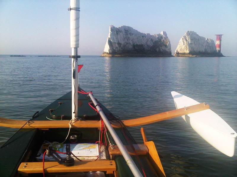
Distances, times and tides: Timing coastal passages to take advantage of tidal streams can be crucial [5].Tides in the Solent and English Channel frequently run at 2 knots or more and at up to 6 knots in places at spring tides. 4 knots of boat speed plus 2 knots of tide equals a combined total of 6 knots whereas, when sailing in the opposite direction against the tide speed across the ground would only be 2 knots. Given the forecast of light winds we assumed a boat speed through the water of 2½ to 3 knots. Our plan was to depart at 07.00, sail 1NM to the end of Hurst Spit, catch the latter part of the ebb, running at 2 to 3 knots, for the 3½ NM down the tidal gate of the Needles Channel [6], arriving at the Needles at about 08.00 – an hour before the tide in the English Channel turned East at around 09.00. The next 3 ½ NM leg would take us East, against the last of the West going ebb tide in the Channel, to Freshwater Bay on the South side of the Isle of Wight. However, it’s often the case that the tide inshore turns sooner than the rest of the tide so we thought we’d be able to make reasonable progress by keeping close inshore next to the tall white chalk cliffs of the island and estimated just over an hour for this part of the voyage.
1½ hours were allowed for landing at Freshwater Bay, making the boats ready to portage and walking them 1¼ land miles northwards along lanes to the head of the River Yar from which it is 1½ NM to Yarmouth – so about ½ an hour’s worth of paddling/rowing. If all went to plan this would see us departing from Yarmouth at about 11.00, leaving 4 hours for the 9½ NM passage with the tide (1 to 2 knots) back to Calshot before the tide turned West at just after 16.00. As previously mentioned, we knew this was going to be tight and there was a possibility of failing to make Calshot before we had a 2 knot tide running against us, giving a speed across the ground of between ½ and 1 knot. So the plan B, pre-arranged with the necessary authorities, was to take the last of the flood up the Beaulieu River [7] to Bucklers Hard and telephone to request Katherine and Ann to collect us and the canoes.
Weather: The forecast was for a very warm sunny day with light winds mainly from South to East but with possibility of South West winds later on Saturday. This meant we’d be likely to be paddling / rowing or paddle sailing for some of the passage when there wasn’t enough wind to sail.
Weather and Navigational Hazards: The Needles Channel can be particularly unforgiving in the wrong conditions. The combination of a fresh or strong South West wind against an ebb tide can whip up huge breaking seas, made worse by the strong tidal stream tumbling over underwater obstructions like the Bridge and Shingles banks. Yachts have foundered in the vicinity in these conditions and there are many wrecks of merchant ships in the area. However, in April we had very different, calm conditions where lack of wind was likely to be the major challenge. We took care in the Needles Channel to avoid being swept onto the Shingles bank, to the West of the channel, or past the Needles turning point by the strong tide. Rocks in the vicinity of the Needles have been the undoing of many yachts participating in the annual Round the Island race but in calm conditions present little hazard to shallow drafted sailing canoes and in the event we were able to sail between the Needles. Landing at the Freshwater bay (very exposed to the South) could be hazardous with swell but there was none. The only other hazard was the large amount of shipping, yachts and launches in some parts of the Solent and Southampton Water but with good visibility we were able to see shipping and other craft in good time and where necessary, take avoiding action.
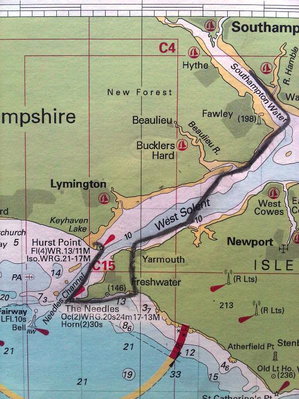
Navigation Plan: This was more about pilotage [8] than navigation in the wider sense and we were familiar with the area. Nevertheless, we all had Solent charts and GPS. Keith had input waypoints along the route into his GPS to indicate the course to steer, whereas Ian and I tended to rely more on our boat (steering) compasses. Canoe sailors often use OS maps instead of charts as sailing canoes are shallow drafted and charts don’t convey much about the nature of beaches, where a landing might be desired. However, the advantages of marine charts include provision of additional information about navigation marks such as buoys, indications of where tidal races and overfalls might be encountered and some tidal stream information. I also carried a waterproof tidal stream atlas showing the strength and direction of the constantly changing Solent tidal streams with pages for each hour before or after High Water (HW) at the reference port of Portsmouth [5]. Mostly, we planned to use parts of the coastline as a series of handrails – firstly, down to the Needles, turn left and on to Freshwater Bay. And later, from Yarmouth – along the island coast almost to Newtown Creek on the right, after which we steered 035° towards the mouth of the Beaulieu River, using Fawley power station chimney in the distance, as a guide. Next, it was just a question of keeping the coast on our left for 3NM and turning left at Calshot for the last leg up Southampton Water.
Skippers and Boats: Keith and I were joined for part of the route (to Yarmouth) by Ian Hylton, a DCA member sailing a Shearwater sailing canoe. We were all experienced and familiar with sailing in tidal waters in a wide variety of conditions. Given the settled weather, the sailing itself (excluding the navigation and planning) was equivalent to an OCSG level 2 sail. Our sailing canoes were all well prepared and previously tested in more challenging sailing conditions.
Kit (in addition to the ‘Coniston kit list’ above): in addition to the navigational items above, camping gear, food and water and extra clothing, I took a fairly extensive assortment of kit including;
- Calling for help, communications and signalling items – marine VHF, personal day/night flare, an assortment of 3 other handheld flares, personal locator beacon and a foghorn.
- I also had – first aid and tool kits, anchor with warp, spare paddle, binoculars, all round white navigation light, small radar reflector, pocket compass and small FM/LW radio for the shipping forecast.
What if: Given the likely relatively low water temperature after the cold winter (I later found it was 12.5°C) we started out with drysuits but soon found it too hot to keep zipped up or to wear at all. However, a capsize was very unlikely given the lack of wind. Fog can be a hazard during spring and early summer months when warm humid air travels in over cold sea but this was unlikely given the lack of wind. However, in the event of poor visibility we could have stayed in shallow water and if necessary put ashore for as long as was needed until it passed.
Sailing the Plan: Lack of wind and a stronger than anticipated foul tide on the South side of the island meant we were frequently paddling or rowing between Hurst and Freshwater Bay. We reached Yarmouth almost an hour later than planned, leaving us just over 3 hours for the 9½ NM to the start of Southampton Water at Calshot before the tide turned West. Worse still, the wind then died almost completely, meaning we had to paddle/row most of the way (mostly with a bit of tide with us) in the hot sunshine. I’d failed to anticipate the need for extra water given the heat and exertion but luckily for me, a DCA acquaintance who is a Marine Police Officer happened to pass by in a RIB while on an exercise, and passed me a bottle of water. In future, I’ll try to remember to take extra water when it’s likely to be warm with little wind. When we reached Calshot a light south westerly breeze arrived to take us back the 3½NM to Netley Sailing Club where we celebrated with a cold beer in the sunshine.
So, if you’ve lasted this far you may now be thinking; is this all really necessary for a short local sail in company on a lake or river? Well, passage planning to the full extent of some of the above would definitely be way over the top but the principle of thinking it through in advance remains the same. For a short sail, I suggest a quick 4 point mental checklist – OCSG.
| Outline a Plan | Weather & Tides, Where to, Who is my rescue partner, Return plan & time, Plan B, Told Someone ashore? |
| Canoe | Boat, Rig, Foils, Fittings all OK for conditions? |
| Skipper | Able to cope with likely Conditions and possible Emergencies? |
| Gear | Buoyancy Aid, Whistle, Paddle, Bailer, Additional Kit (calling for help, navigation or other)? |
Footnotes
1. The Titanic complied with all the safety standards of the day. SOLAS addressed the need for higher standards.
2. Since 1958 SOLAS has been governed by the International Maritime Organisation (IMO). SOLAS is backed by force of law in the jurisdictions of IMO member countries.
3. ‘Towards’ is often used when referring to sailing destinations in passage plans, log books and such. ‘Towards’ seems to me to reflect the provisional nature of plans and indicates more of an aspiration than a certainty, whereas the alternative of ‘to’ seems to tempt fate.
4. The March 2011 Gossip has an account of a February sail in much the same area, but in very different conditions.
5. High Water Portsmouth was at 03.29 and 16.08 BST. It was 5 days after full moon, so tides were close to springs.
6. A ‘tidal gate’ usually refers to a location (often a narrow passage or just off a headland) where there are strong tidal streams, which it would be difficult to make any progress against, should an arrival be late or mistimed.
7. One of the several unusual features of Solent tides is that the tide starts to ebb, or turn West, in the main part of the Solent one hour before high water. This means that the many natural harbours and rivers of the area are still experiencing the last of the flood as the ebb starts in the Solent.
8. ‘Pilotage’ refers to the use of visual references such as landmarks, leading lines and seamarks (e.g.buoys), possibly in conjunction with a chart, for navigation within sight of land.
9. For a 1968 ‘Joe & Petunia’ short public information cartoon about calling the Coastguard see www.nationalarchives.gov.uk/films/1964to1979/filmpage_coastguard.htm .
10. Contrary to the findings of the 1912 Lord Mersey enquiry into the Titanic disaster, the great majority of deaths were not caused by drowning but rather by cold water shock or hypothermia following immersion in seawater at minus 2°C. See www.timeshighereducation.co.uk/story.asp?storyCode=169325§ioncode=26 100 years later the dangers of cold water continue to be underestimated. Studies have indicated as many as 50% of UK deaths attributed to drowning have as the underlying cause, incapacity due to cold water shock or hypothermia (two distinct phases of the body’s reaction to cold water). UK sea and lake temperatures are mostly within a seasonal range of 5 to 16°C. Even at 16°C, for a person in average clothing, the onset of hypothermia leading to eventual incapacity (including inability to swim or use hands effectively and mental confusion) can start after as little as 1 hour. At 5°C, in under 30 minutes. A drysuit will greatly delay the onset of hypothermia.
11. For more information on cold water shock and hypothermia see; http://ftp.rta.nato.int/public//PubFullText/RTO/AG/RTO-AG-HFM-152///AG-HFM-152-03.pdf orwww.ussartf.org/cold_water_survival.htm .
12. Harold Phillimore survived the sinking of the Titanic, being the last person to be rescued from the freezing water by lifeboat and went on to serve in the Merchant Navy, dying in Winchester in 1967.